Turn by Turn Directions
We leave the picturesque Bolam Lake Park and head west across the fields passing through Low Angerton, Meldon, Molesden, Mitford and Morpeth. This is a great walk which takes in many of Northumberland’s best villages on our way.
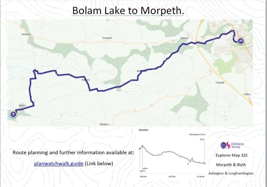
It is best to undertake this walk with the OS Explorer Map 325 (Morpeth & Blyth), and compass, as we will be taking footpaths and bridleways which are not always signed.
Bolam Lake
Start the walk at Bolam Lake car park, if you have not already, why not take a walk around the lake itself. Time nicely invested. We leave the NW car park and head up the road to the T junction and head left towards Bolam.
Bolam
As we pass Bolam Hall on our left there is a small dog leg in the road and we head left towards Bolam church. We head past the church on our right and head off across the fields heading north.
Low Angerton
When we reach Low Angerton we need to pick up the byway heading East, which is a really pleasant walk, we eventually come to metal farm gate with Howlett Hall on our right; we head up the slope to Howlett Hall
Howlett Hall
As we leave the farm buildings behind us, we pass over a small brook and turn left (West) and head across the side of the fields. Some way ahead of us we can see some trees with farm structure/equipment showing above. We head towards this wooded area.
Meldon
As we reach Meldon Farm we pick up a road and turn right (South) and walk through the small village. Meldon is one of 51 Thankful Villages in the UK that suffered no fatalities during the Great War of 1914-18. As we leave Meldon we continue along the road heading south until we reach the T Junction, where we turn left (East) and follow the road until we get to the sign for Penny Hill on our left, and continue passing the farm on our left.
Penny Hill to Molesden
As we leave Penny Hill farm behind us, we walk along the side of the fields and head to the wooded area, then following the signed path through the woods. At the time of walking there were many trees across the path, due to high winds. Be careful not to loose the path when walking around the trees, us your compass to keep you on track.
When we leave the wooded area, we head NE and pick up the dismantled railway. After following this path for a short while, we come to a farm gate on our left and head down the side of the field towards Molesden, which we can see ahead of us.
Molesden
We pick up the road in Molesden and head right (East) along the road until we come to a sharp right hand bend. We take the signed path straight ahead of us, heading up the side of the field. About a mile ahead of us we can see a wooded area, we are heading for this, as we do we pass over a number of burns and small bridges, be careful, some are not in the best of order.
Mitford.
Once we have walked along the side of the wooded area we can see Mitford Hall on our left (North) as we come to a small road, we turn left and head down the incline towards Mitford. We can see the remains of a disused caste on our right and the picturesque on our left. Before we reach the bridge we take the signed path on our right and head along the side of the River Wansbeck.
We continue on this path, which takes us slightly away from the river at points. We actually walk under the main A1 road from Newcastle heading north.
We continue along the signed path for Morpeth.
Morpeth.
We eventually come out onto the Morpeth to Mitford road, where we turn right and head towards the bridge for around 100m. We do not take the bridge, but head down the path ahead of us. We follow this path along the side of the River Wansbeck, which will take us onto the centre of the Market Town of Morpeth and the conclusion of the very enjoyable walk.
Outdoor Catch-Up:
PWW searches for the best outdoor clothing offer and circulates these through our Outdoor Catch-Up communication, don’t forget to subscribe to some of the best offer available, we do the hard work for you. Subscribe at www.planwatchwalk.guide/outdoor-catch-up
Mapping and Directions:
OS Map App – Ordnance Survey Maps and routing – https://tidd.ly/3Xi32AJ
Maps – Ordnance Survey Maps – https://tidd.ly/3vTKOK0
Compass – Must have – https://tidd.ly/3XeDynV
Equipment used:
Jacket – Rab Microlight Alpine Jacket – https://tidd.ly/3iqUU26
Jacket – Montane Gravity Gore-Tex Jacket – https://tidd.ly/3Zq6HhF
Footwear – Merrell Accentor Sport GTX – https://tidd.ly/3Czkqct
Boots – Scarpa Rush Trek GTX – https://tidd.ly/3IHWEyu
Trousers – Montane BMC Terra Pants – https://tidd.ly/3QoR3iq
Waterproof Trousers – Mountain Hardwear Epic Pant – https://tidd.ly/3CveZeo
Socks – 1000 mile wool fusion double layer – https://tidd.ly/3ZqdIz1
Head Torch – Lifesystems Intensity 220 Head Torch – https://tidd.ly/3k0zsBo
Backpack – Hi Gear Active22 – https://tidd.ly/3k5Rgva
Bladder – Camelbak 2.5L Hydration Reservoir – https://tidd.ly/3inJX18
Camera Kit
GoPro 5 – Go anywhere action camera – https://amzn.to/3WV2OQ5
hohem iSteady Pro 4-Gimbal stabiliser – Making your video professional – https://amzn.to/3Xi1BCs
Lavalier Microphone – Capture professional audio – https://amzn.to/3XfjP7p
Insta360 ONE X2-360 Degree Camera – brining video to a new dimension – https://amzn.to/3jSgo8i
Insta360 3M (10ft) Invisible Selfie Stick – make it look like a drone – https://amzn.to/3VXf8hu
This post contains affiliated links, and I may earn a small commission when you click and purchase through these links. This is at no cost to you. Thank you for your support.