Turn by Turn Directions
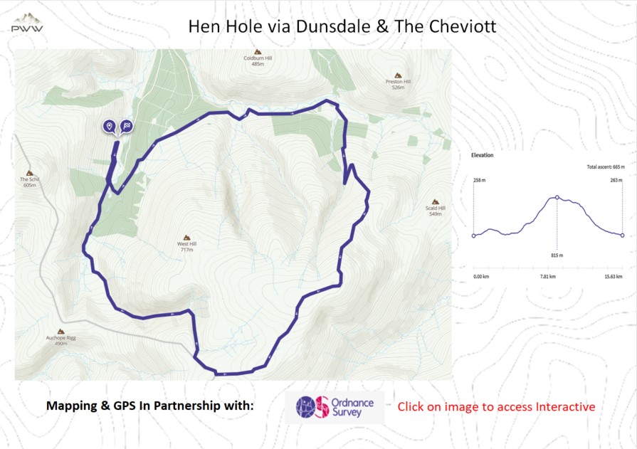
After parking up (Google PIN available on start point link below) next to Mounthooly, we head south along the path. On our left is a wooden footbridge (Video 1.50), where we cross the stream and head into the wooded area. We quickly get a great view back over College Valley (Video 2.20), which sets the scene for a great days walking.
We follow the edge of the wooded area as we head towards Dunsdale (Video 3.47). We take the single track road east, alongside Lambden Burn towards Goldscleugh (Video 4.30). This is the start of a long steady climb to The Cheviot summit.
After we walk up the side of the wooded area, we have couple of options. You can continue up the path, or take a detour to a waterfall (Video 6.10). Once the tranquil waterfall has been visited, we once again pick up the track (Video 6.30). Don’t forget to take time to admire the magnificent views on the way (Video 7.00).
Once the steady climb is complete, we head along the paved track towards The Cheviot (Video 8.20). I generally take a break at the trig point, before continuing. Now picking up the Pennine Way path, we head south west, passing signage on the way (Video 10.30). Continuing on The Schil signed path, we turn right (north) before reaching Auchope Cairn (Video 11.15). We now enter Hen Hole (Video 12.00) following the College Burn, with many magnificent waterfalls (Video 13.00). It is hard to describe the tranquillity of this stage, all I can say is it is a true pleasure. This said, the walk along the Burn can be tricky as there is no path (Video 13:45). The terrain contains scree, large rock formations and some drop offs, so please be careful. The rewards are worth it. We come to the Three Sisters Waterfall (Video 14.30).
After leaving Hen Hole, we follow the College Burn to the conclusion of our walk.
This is not the easiest of walks, but the rewards are truly amazing. If you are able to undertake the walk, you should add this one to your bucket list. Enjoy.
Join us at our YouTube Community
Outdoor Catch-Up:
Why not sign up to Plan Watch Walk ‘Outdoor Catch-Up’, a fortnightly circular with all of the best deals.
Mapping and Directions:
OS Map App – Ordnance Survey Maps and routing
Maps – Ordnance Survey Maps
Compass – Must have
Equipment used:
Jacket – Rab Microlight Alpine Jacket – Equipment Review
Jacket – Montane Gravity Gore-Tex Jacket
Footwear – Merrell Accentor Sport GTX
Boots – Scarpa Rush Trek GTX – Equipment Review
Trousers – Montane BMC Terra Pants
Waterproof Trousers – Mountain Hardwear Epic Pant
Socks – 1000 mile wool fusion double layer
Head Torch – Lifesystems Intensity 220 Head Torch – Equipment Review
Backpack – Hi Gear Active22
Bladder – Camelbak 2.5L Hydration Reservoir
Camera Kit
GoPro 5 – Go anywhere action camera
hohem iSteady Pro 4-Gimbal stabiliser – Making your video professional
Lavalier Microphone – Capture professional audio
Insta360 ONE X2-360 Degree Camera – bringing video to a new dimension
Insta360 3M (10ft) Invisible Selfie Stick – make it look like a drone
This post contains some affiliated links, and I may earn a small commission when you click and purchase through these links. This is at no cost to you. Thank you for your support.

