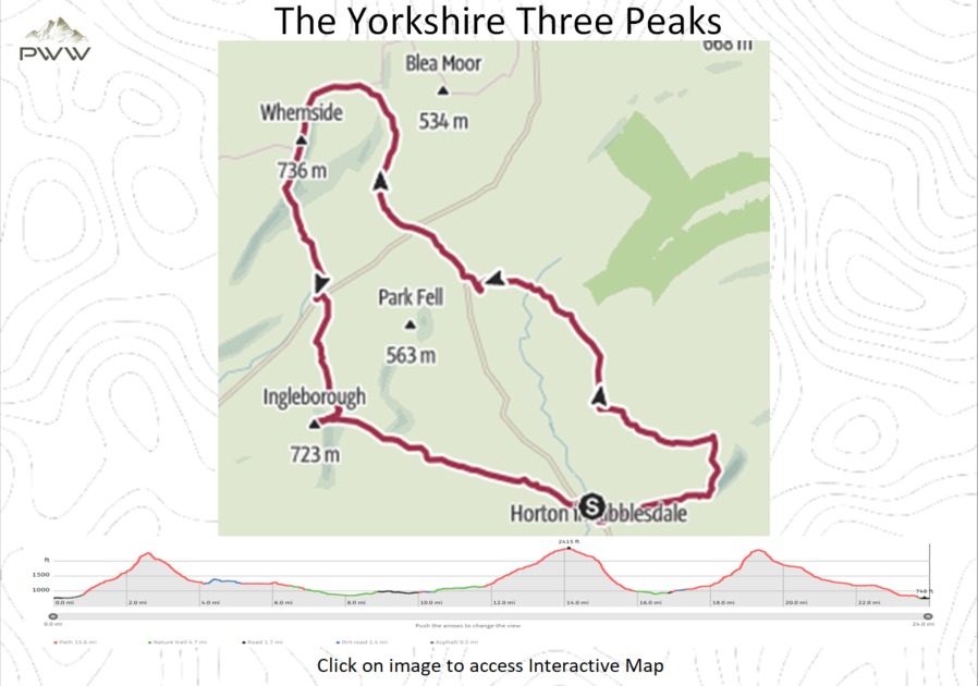
Horton in Ribblesdale to Pen-y-ghent (2.5 Miles).
We leave the car park (see start location link below), and turn right (head South) for around 100mtr and turn left (Video 1:50). Head up the path following the signs for the Three Peak Trail. You will find throughout the walk that the route signs are very good, with a couple of exceptions. We quickly leave the farm tracks and head up onto the fells, where we are quickly rewarded with views up the valley. As we continue to follow the trail, through gates and over stiles, we reach the start of the climb up to the summit of Pen-y-ghent (Video 3:50). It is worth making sure of your footing as you climb up the rock and boulders underfoot. Once on the summit of (Video 4:50) we are rewarded with some fantastic panoramic views in all directions, from the trig point (2276ft). We have now covered 2.5 miles and have a further 21.5 miles remaining. Take some time to refresh for the next leg.
Pen-y-ghent to Whernside (11.5 Miles).
On leaving Pen-y-ghent, climbing through the divide in the wall and picking up the signs for the Three Peak Trail. The paths from here to Whernside are well established, with good signage along the way. We now drop in to the long stretch of relatively flat walking as we head along to the Ribblehead Viaduct, which is part of the Settle to Carlisle train route.
As we walk through the valley base along paths and across fells, we are treated to some beautiful scenery on the way. It is more than likely that you will pick up with other walking groups and share your own experiences so far.
We head over the River Ribble (Video 7:35), continuing past the farm buildings. Then join the road (B6479) and turn right (heading North). This can be busy, so be careful for the next mile or so. As the Ribblehead Viaduct comes into view, we come to the T Junction. It’s normal to have a couple of beverage and food vans here, should you need some refreshments and a quick break.
We continue over the T Junction along the path with the viaduct on our left, hopefully you will be lucky enough to see a train on the viaduct (Video 9:00). The path takes us along the Eastern side of the rail line for around 1.5 miles. Note: we pass a sign for Whernside on our left under the rail line, this we ignore and continue along the path. The path then starts a long steady climb up to the summit. I would advise taking a steady pace as the climb is over a mile in length.
Once at the trig point (2415ft) we can see the peaks of Pen-y-ghent (first peak) and Ingleborough (third peak), which gives you a really good idea of the distance travelled so far (14 miles), and distance to go (10 miles). I tend to stop here for a while to take on some food and liquids.
Whernside to Ingleborough (5.5 Miles).
When leaving (Video 11:00), we continue along the ridge and follow the path, heading South and descending into the valley. Once back in the valley, it is nice to take some of the strain off the legs on the flat surface. We find ourselves on Philpin Lane and shortly before reaching the junction of the B6255, we pass some farm buildings on our right, where you can pick up some refreshments (Video 13:35). At the junction of the B6255 we turn left, this is the only point where The Three Peaks signage is missing. Around 150 mtrs along the road, after passing The Old Hill Inn, the path is once again signed on our right. Back on the fells, we continue along the well-defined track with Ingleborough ahead of us. The climb is gentle and steady until we come to the final near vertical climb to the top of Ingleborough (Video 16:20). This is not too welcoming, as we have already completed around 20 miles of walking. On our way to the top of Ingleborough (2372ft) there is scree and many boulders to contend with, so take it gently.
Once again it is worth taking a few moments to take in the views from the trig point.
Ingleborough to Horton in Ribblesdale (4.5 Miles).
Upon leaving the summit, we retrace our track off the top and pick up a track on our right, which takes us in a Westerly direction heading down the path stretching out ahead of us. The walk back to Horton in Ribblesdale is relatively easy on the limbs, although I always find that this takes longer than expected. It takes around two hours from leaving Ingleborough summit to reach Horton in Ribbledale, that said the walk is very pleasant, crossing the fields and fells.
As we reach Horton in Ribblesdale we need to cross the tracks of the Settle to Carlisle rail line. As we continue down the road, there is a wooden footbridge on our right, over the River Ribble. This takes us back to the car park, and our conclusion of the challenge.
Now you can rest your tired limbs, and reflect on a good day.