Conquering Skiddaw via Longside Edge, Tracing Wainwright’s Steps
October 13, 2023
Stay Fresh and Active with Keela Men’s Trail Trousers (featuring Polygiene ViralOff)
November 13, 2023

Embrace the serenity of the Cheviot Hills, as we explore Harthope Linn & Hedgehope Hill

Embark on an exhilarating adventure in the Cheviot Hills! Join me on a captivating journey as we explore the Harthope Burn, Harthope Linn, and the stunning vistas of Comb Fell and Hedgehope Hill. The Harthope Burn will serenade us with its gentle murmurs, guiding our path through lush woodlands and hidden treasures.  Our destination: the breathtaking Harthope Linn, a hidden gem concealed within the heart of the hills. Prepare to be spellbound by its cascading waterfalls and pristine pools.  Our grand finale takes us to Hedgehope Hill, the second-highest peak in Northumberland.

Other resources:

Don’t forget to access/download the full route and mapping on OS Maps for this route.

Choose the best equipment at Plan Watch Walk equipment reviews.

All of our Lake District walk videos can be found here

Why not sign up to Plan Watch Walks ‘Outdoor Catch-Up’, a fortnightly circular with all of the best deals Sign up here

Turn by Turn Directions

Are you ready for an unforgettable adventure in the heart of Northumberland? We park up next to Hawsen Burn, to the east of Langleeford. Getting kitted up with such a wonderful backdrop is a pleasure in itself. We start off heading south-west along the road (Video 1:15). After only around 300m, we pass the route to The Cheviot (Video 1:50) before we continue along the path to Langleeford Farm (Video 2:30). Passing the farm, we continue along Harthope Burn on the northern path. The walking is so pleasant, and you get a great view of our route today (Video 3:40). We very gently ascend along the valley, passing Langleeford Hope (Video 4:20) on our way until we come to Harthope Linn (Video 4:50). You need to be a little careful when heading down into the gorge.

We continue our walk along the route of Harthope Burn, taking in the tranquillity as we go. Don’t forget to look behind (Video 6:20), as you have some great views along the valley. Harthope Burn gives us so much beauty with further waterfalls, and we eventually crisscross (Video 6:40) on our way to the head of the valley (Video 7:20).

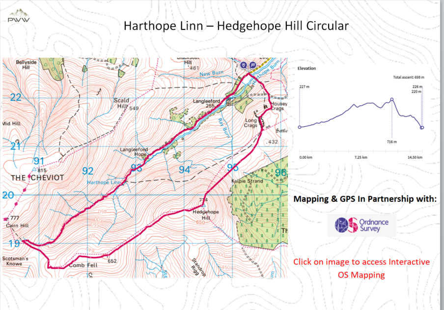
Our route now heads south and then east as we climb onto Comb Fell, following the fence on our way. A pair of gaiters would be an advantage at this point, as the peat and bogs can be a challenge. We follow the fence as our guide, peaking on Comb Fell, before ascending before our climb to the summit of Hedgehope Hill, the second-highest peak in The Cheviots. Care is needed at this point as the peat bogs can remove your footwear (Video 11:06). The climb up to Hedgehope Hill is steady but not too difficult. As we reach the summit, the views are quite breathtaking, over the Cheviot Hills and down to the Northumberland coast. When I undertook the walk, I was in low-level clouds (Video 12:15), which was such a shame.

The descent from Hedgehope Hill is a little steep, and a pair of walking poles always helps. As we descend Hedgehope, we can see our path heading towards Long Crags and Housey Crags (Video 13:40). The path to Long Crags is well-trodden, and we get a great view of the route we have just walked, from a vantage point on Long Crags (Video 14:30).

Our route off the hills is well-defined, as we pass Housey Crags (Video 5:50). We reach the valley and have one further cross of Harthope Burn (Video 16:40) before meeting up with your car and the conclusion of what has been a great walk of two distinctive halves.

Discover the mesmerizing beauty of Northumberland as you explore Hedgehope Hill and Harthope Burn. This is an adventure that will stay with you for a lifetime, offering a perfect blend of nature, tranquillity, and breathtaking views.


Outdoor Catch-Up:

Why not sign up to Plan Watch Walk ‘Outdoor Catch-Up’, a fortnightly circular with all of the best deals.

Resources used whilst bringing you this walk…


Mapping and Directions:

OS Map AppOrdnance Survey Maps and routing

Maps Ordnance Survey Maps

Compass Must have


Equipment used:

JacketRab Microlight Alpine JacketEquipment Review

Jacket Montane Gravity Gore-Tex Jacket

FootwearMerrell Accentor Sport GTX

Boots – Scarpa Rush Trek GTXEquipment Review

TrousersMontane BMC Terra Pants

Waterproof TrousersMountain Hardwear Epic Pant

Socks1000 mile wool fusion double layer

Head TorchLifesystems Intensity 220 Head TorchEquipment Review

Backpack Hi Gear Active22

BladderCamelbak 2.5L Hydration Reservoir


Camera Kit

GoPro 5Go anywhere action camera

hohem iSteady Pro 4-Gimbal stabiliserMaking your video professional

Lavalier MicrophoneCapture professional audio

Insta360 ONE X2-360 Degree Camerabringing video to a new dimension

Insta360 3M (10ft) Invisible Selfie Stickmake it look like a drone

This post contains some affiliated links, and I may earn a small commission when you click and purchase through these links.  This is at no cost to you.  Thank you for your support.

Embrace the serenity of the Cheviot Hills, exploring Harthope Linn & Hedgehope Hill

Join me on a captivating journey as we explore the Harthope Burn, Harthope Linn, and the stunning vistas of Comb Fell and Hedgehope Hill.

Hard

9.0 miles

OS Explorer OL16

4.5

Start Point