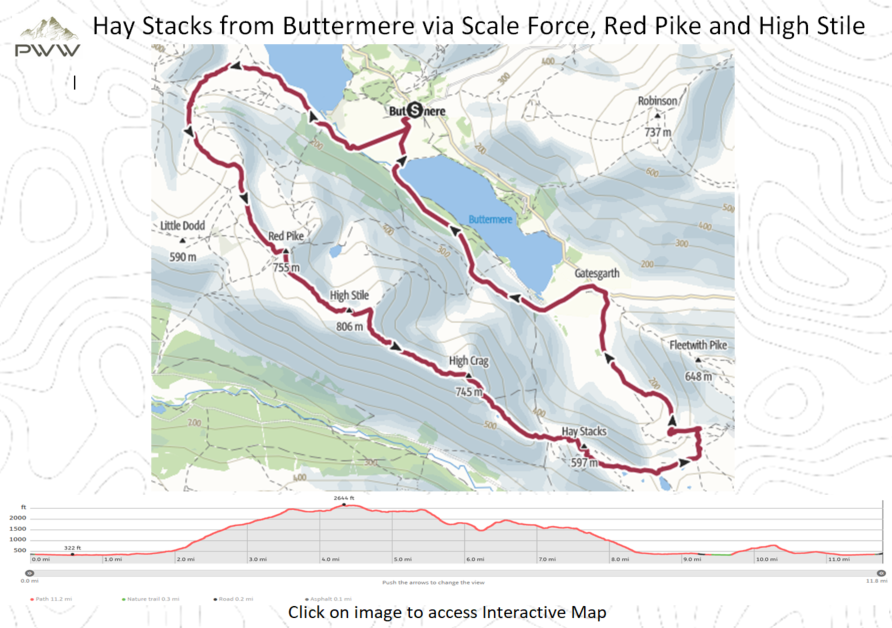
Buttermere Village. The village of Buttermere lies between the Lake District lakes of Buttermere and Crummock Water, and is overlooked by the summits of Grasmoor to the north and High Stile to the south. Buttermere church is dedicated to St James, and dates from 1840, replacing a chapel which was dedicated in 1507. It has a memorial plaque to Alfred Wainwright, in the sill of a window with a view of Haystacks, where his ashes were scattered. Buttermere Village to Scale Force (2 miles) With Buttermere Village behind, we head South across the fields with Buttermere and Crummock Water on either side. Once over the fields, the path leads to Scale Bridge (Video 1:30). Continue to follow the path along the side of the Crummock Water. Once we pass Scale Island (on our right) we start to head away from the lake, on a well-trodden path. There is a gentle incline along the way as we head towards Scale Force. We can hear the water fall before we arrive (Video 3:10) It is worth taking some time to view the magnificence of the falls. The highest waterfall in the Lake District is Scale Force with a single drop of 170 ft, and two others of about 20 ft. It is hidden away in a deep tree-lined gorge. Scale Force to Red Pike (1.5 miles) Leaving Scale Force we head up the southern bank of Scale Beck, heading up the valley gorge as we climb. Take some time to look behind you on the way, as the magnificent views start to appear. The path is well defined and trodden, sign posted by many cairns on the way. As we reach Lingcomb Edge we have an excellent view of Red Pike ahead of us. The path remains well defined as we head towards our first summit at 755 Mtrs (Video 6:10) Red Pike to Hay Stacks (3 miles). When this walk was undertaken the tops of Red Pike and High Stile were in the cloud base and visibility was poor, subsequently navigation was difficult along the path. This said, there were many posts and cairns along the route, which made navigation possible. Fortunately the cloud base lifted at Eagle Crag, revealing, what appeared to be a 1000ft drop off (Video 7:30). Now that there was some visibility, the true majesty of the walk became apparent. From here on in it was possible to see the path leading ahead of us, over High Crag and onto Hay Stacks. The walking was steady over High Crags, although there are many ascents and descents along the way. We now have Hay Stacks ahead of us. The name Haystacks derives from the appearance of the summit cliffs. According to Wainwright, the name comes from the Icelandic stack meaning ‘a columnar rock’ and the correct translation of this should be High Rocks. The route over Haystacks can be steep, with many gullies to navigate on our path (Video 8:30). Hay Stacks really does feel as if it has its own personality, it’s very hard to explain. Hay Stacks to Buttermere Village (5 miles). We sadly need to leave Hay Stacks. This is undertaken by taking the path via Innominate Tarn and Blackbeck Tarn, which are both very picturesque (Video 10:20). If you have time, it is refreshing to pause and take a break at this point. From here we are able to see the path around the valley and down towards Buttermere (Video 11:15). Descending along Black Beck we have some great views of the many waterfalls along the path (Video 13:05). Once back in the valley we pass Gatesgarth Cottage on our left, and shortly after, we turn left and head across the fields, with Buttermere on our right. The remainder of our walk is along the shores of Buttermere, which gives time to reflect on what has been a challenging but memorable days walking. | 
