Equipment Review – Craghoppers Tarbert Half Zip Fleece
July 6, 2023Equipment Review – 1000 Mile Socks – Field Trial.
July 10, 2023Equipment Review – Craghoppers Tarbert Half Zip Fleece
July 6, 2023Equipment Review – 1000 Mile Socks – Field Trial.
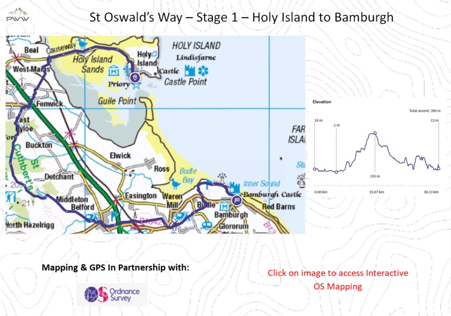
July 10, 2023St Oswald’s Way – Stage 1 – Holy Island to Bamburgh.
This is the first stage of the 97 mile St Oswald’s Way, taking us from Holy Island to Bamburgh on this 19 mile walk. We take in many historical sites, with some stunning views. The walking is varied and immensely enjoyable.
.
Other resources:
Why not sign up to Plan Watch Walk ‘Outdoor Catch-Up’, a fortnightly circular with all of the best deals.
Need to get the right equipment for your walk – explore our reviews.
Turn by Turn Directions
We commence the walk on Holy Island in northern Northumberland. Remember you must check the local tide tables before starting this walk as you can only cross the causeway to the mainland on low tide, further info can be found here. There are many points of interest to explore on the island, including Lindisfarne Castle, Lindisfarne Priory and Lindisfarne Harbour, these can be viewed in the video From 4:30.
We head towards the causeway and have a couple of options for our crossing, either by following the causeway or by taking the Pilgrims Route across the sands and following the posts. In the video, I took this route (Video 6:00), which adds to the experience.
Once on the mainland, we follow the signage, which takes us south (Video 8:50). We head over the fields, where the tranquillity is good for the soul. Following the signed route, we have some great views over to Holy Island. Our route takes us to a rail crossing of the main north-south east coast line. You will need to ring the control room for permission (Video 10:40). Continuing along the route, we come to the A1 north-south trunk road. Please be careful when crossing. We need to undertake both of these crossings later in this section.
Passing through Fenwick (Video 12:40), we head up the road and a slight incline, until we get to Blawearie (Video 13:10) and continue across the fields towards the wooded area. It is worth taking some time to appreciate the views on the way (Video 13:50). Our walk through Shiellow Woods is very pleasant.
Upon exiting the woods (Video 16:50) we once again have some great views from Bamburgh Castle to Holy Island and the magnificent scenery in between. We shortly reach the point where we leave St Cuthbert’s Path (Video 17:30), and continue southeast.
We come to Virgin Hill Woods, and it is worth taking in the delights of Lower Swinhoe Lake (Video 18:20). We pass through Swinhoe Farm (Video 18:50) and pass The Hag (Video 19:20) on our way to Belford (Video 20:25).
Leaving Belford, we head along Belford Burn (Video 21:20) and cross the A1 once again (Video 21:30), before undertaking our second cross on the rail line (Video 22:10). Our route now takes us across open fields, on our way to Warren Mill. We pass Warren Burn (Video 23:45) and head through Spindlestone Heughs (Video 24:10), which is a great section of the walk. We pass through Warren Mill Caravan Park and have a small section along a country road. At the next junction, we have some great views of Bamburgh Castle (Video 24:50). Continuing across the fields we come to our next junction, where the views of the castle only improve (Video 25:22).
The route takes us north for a small section along the road before we head over the golf course. We now get some great views across Budle Bay (Video 25:50). As we head along the dunes, there are two larger dunes, it is worth taking a slight detour to make the most of the 360o views (Video 27:05), and you can track the route you have taken from Holy Island.
As we conclude, what has been a magnificent walk, we head towards the lighthouse (the most northern in England) and Stag Rock (Video 27:50). The view of Bamburgh Castle and the beach will stay with you for a long period.
We now have a nice stroll into Bamburgh and the conclusion of the first stage, and the anticipation of what lies ahead in stage two.
Outdoor Catch-Up:
Why not sign up to Plan Watch Walk ‘Outdoor Catch-Up’, a fortnightly circular with all of the best deals.
Resources used whilst bringing you this walk…
Mapping and Directions:
OS Map App – Ordnance Survey Maps and routing
Maps – Ordnance Survey Maps
Compass – Must have
Equipment used:
Jacket – Rab Microlight Alpine Jacket – Equipment Review
Jacket – Montane Gravity Gore-Tex Jacket
Footwear – Merrell Accentor Sport GTX
Boots – Scarpa Rush Trek GTX – Equipment Review
Trousers – Montane BMC Terra Pants
Waterproof Trousers – Mountain Hardwear Epic Pant
Socks – 1000 mile wool fusion double layer
Head Torch – Lifesystems Intensity 220 Head Torch – Equipment Review
Backpack – Hi Gear Active22
Bladder – Camelbak 2.5L Hydration Reservoir
Camera Kit
GoPro 5 – Go anywhere action camera
hohem iSteady Pro 4-Gimbal stabiliser – Making your video professional
Lavalier Microphone – Capture professional audio
Insta360 ONE X2-360 Degree Camera – bringing video to a new dimension
Insta360 3M (10ft) Invisible Selfie Stick – make it look like a drone
This post contains some affiliated links, and I may earn a small commission when you click and purchase through these links. This is at no cost to you. Thank you for your support.
Other Walks & How to equipment guides you may be interested in:
Other Walks:
Ingram Valley – Linhope – Ravenhill
Hen Hole, Three Sisters, Dunsdale & The Cheviot – What Great Walking.
Historic Market Town of Morpeth, Surrounding Countryside & River Walking.
Simonside Hills Circular in the Northumberland National Park.
Expert Review links:
Plan Watch Walk – Expert Reviews.