The Goatstones is a Bronze-Age four-poster stone circle located near Ravensheugh Crags in Northumberland, England. It is 2.5 miles (4.0 km) to the north of Hadrian’s Wall in the parish of Wark-on-Tyne. The name is thought to be derived from the Saxon “gyet stanes” meaning “wayside stones”.[1] The monument probably had some kind of religious purpose.[2]
The stones are no higher than 80 centimetres (31 in), and are separated by a distance of approximately 4 metres (13 ft). The smallest stone is decorated with 13 cup marks, or small depressions in the rock, a well known form of prehistoric rock art in Northumberland. The Goatstones is the only recorded example of a four-poster stone circle bearing cup marks. Grooves can be seen on some of the other stones.[3] Within the circle there are traces of a low mound. This is thought to be the remains of a stone cairn which predates the construction of the stone circle and may have been the site of Bronze-Age burials.[4]
Four-poster stone circles are found mainly in Scotland, particularly in Perthshire, and more rarely in Ireland, Wales and England. Another example in Northumberland is the Three Kings in the parish of Rochester.
Turn by Turn Directions
This route is mainly on tracks, paths where clear signage is mostly available. I would always advise to take OS Maps and OS GPS, where this route is available for your use, links can be found below.
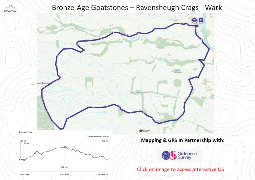
We leave Wark and head south along the road with the River Tyne on our left before turning right towards Latterford (Video 2:10). We continue on the marked path crossing the Ford between Latterford and Latterford Doors (Video 2:45) on our way to Conshild. We have a gentle climb with some great views (Video 3:55), before passing Allgood Farm and arriving at another Ford on our path (Video 5:00).
We continue on a well-defined path, with a wooded area on our right and onward to Pit Wood. Then passing a farm on our left by Coal Burn as we continue to Ravensheugh Crags (Video 5:45), the trig point and The Bronze age Goatstones (Video 7:10).
Leaving The Goatstones we continue along a well-used track before turning right (Video 9:20). After crossing Ward Lane we continue towards Golfton Fieldhead and onward to Ravenshaugh (Video 11:45). We continue on the path for around half a mile, crossing Warks Burn, before taking a path marked for Woodley Shields (Video 12:10). We follow this path to the conclusion of our walk in Wark, after what has been a great days walking.
Mapping and Directions:
OS Map App – Ordnance Survey Maps and routing – https://tidd.ly/3Xi32AJ
Maps – Ordnance Survey Maps – https://tidd.ly/3vTKOK0
Compass – Must have – https://tidd.ly/3XeDynV
Equipment used:
Jacket – Rab Microlight Alpine Jacket – https://tidd.ly/3iqUU26
Jacket – Montane Gravity Gore-Tex Jacket – https://tidd.ly/3Zq6HhF
Footwear – Merrell Accentor Sport GTX – https://tidd.ly/3Czkqct
Boots – Scarpa Rush Trek GTX – https://tidd.ly/3IHWEyu
Trousers – Montane BMC Terra Pants – https://tidd.ly/3QoR3iq
Waterproof Trousers – Mountain Hardwear Epic Pant – https://tidd.ly/3CveZeo
Socks – 1000 mile wool fusion double layer – https://tidd.ly/3ZqdIz1
Head Torch – Lifesystems Intensity 220 Head Torch – https://tidd.ly/3k0zsBo
Backpack – Hi Gear Active22 – https://tidd.ly/3k5Rgva
Bladder – Camelbak 2.5L Hydration Reservoir – https://tidd.ly/3inJX18
Camera Kit
GoPro 5 – Go anywhere action camera – https://amzn.to/3WV2OQ5
hohem iSteady Pro 4-Gimbal stabiliser – Making your video professional – https://amzn.to/3Xi1BCs
Lavalier Microphone – Capture professional audio – https://amzn.to/3XfjP7p
Insta360 ONE X2-360 Degree Camera – brining video to a new dimension – https://amzn.to/3jSgo8i
Insta360 3M (10ft) Invisible Selfie Stick – make it look like a drone – https://amzn.to/3VXf8hu
This post contains affiliated links, and I may earn a small commission when you click and purchase through these links. This is at no cost to you. Thank you for your support.

