Isaac’s Tea Trail –Alston to Allendale – Day 2 of 2
February 4, 2025
Exploring the Historic Treasures of Northumberland: Etal Castle, Duddo Tower, and Beyond
February 10, 2025

Winter Walk to Pikeriggs Currick: A Stunning December Hike.

My latest adventure took us deep into the Northumberland countryside, starting from Slaggyford on a crisp December morning. The frost-laced landscape set the scene as we made my way past Wardley Law and Whitefield Law, gentle hills rolling under the low winter sun.

The highlight of the walk was reaching our Trig Point at Pikeriggs Currick, standing proudly at 525 meters. From here, we soaked in breath-taking panoramic views, the clear skies offering a perfect backdrop to the rugged beauty of the North Pennines.

My return journey took us via Whitefield Lough, its still waters reflecting the winter sky, before following the River South Tyne back towards Slaggyford. The peaceful riverbank, dusted with frost, was the perfect way to end a truly spectacular day in the great outdoors.

A fantastic winter hike full of stunning scenery, fresh air, and a real sense of adventure!


Other resources:

Don’t forget to access/download the full route and mapping on OS Maps for this route.

Choose the best equipment at Plan Watch Walk equipment reviews.

All of our Northumberland walk videos can be found here

Why not sign up to Plan Watch Walks ‘Outdoor Catch-Up’, a fortnightly circular with all of the best deals Sign up here

Turn by Turn Directions

Starting the walk just south of Slaggyford (see start point link below), you head over the bridge (see Video at 1:00).  Continue down the path bearing left towards Williamston Barns (see Video at 1:40).  After passing the properties, you come to you bear right and head along the path ascending gently.  At this point, you are already picking up some of the great views you are going to experience on the walk (see Video at 2:40).  Shortly, you will come to the gate on your left (see Video at 3:30), which we need to take.  It is worth downloading the OS GPS Map onto your phone for this walk. You can find it by clicking the map below.


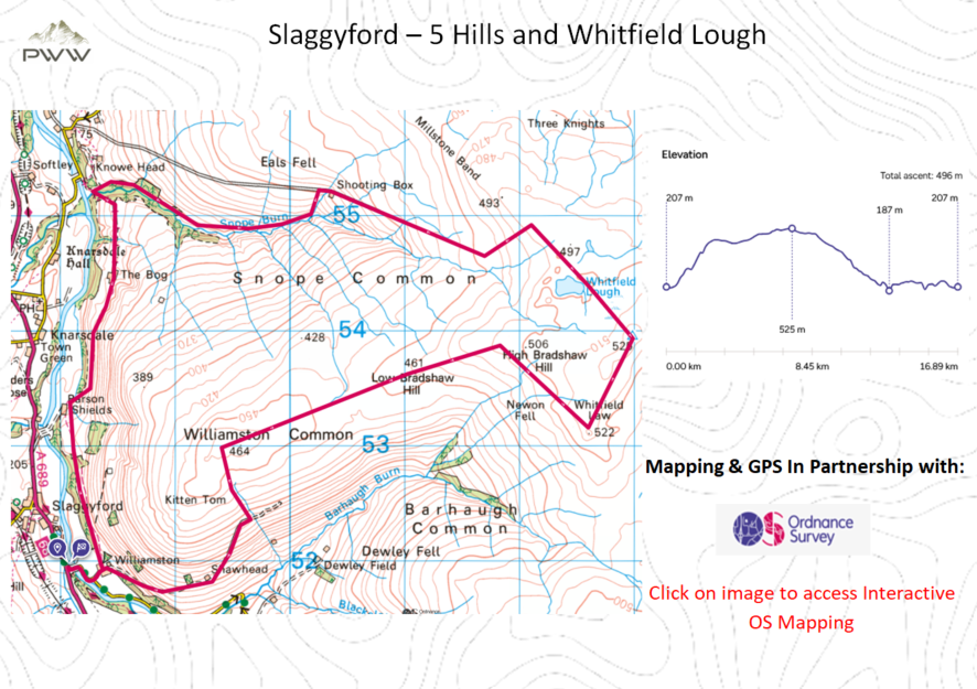
Once through the gate, you continue your gentle ascent following the stone shooting hides and the path Blackley Spike, which will take you to Wardley Law at 464 meters. The terrain here is flat as the views north start to open up (see Video at 4:35), and you head towards the fence.  Once you reach the fence, you head west for some period, following the path of the fence and dry stone wall. Don’t forget to look all around you at the views that keep evolving.  You will come to the end of the dry stone wall (see Video at 6:45).  We need to head off-piste across the ferns and bogs towards Whitfield Law at 522 meters.  It is worth having waterproof footwear and gaiters for this section.


Reaching Whitfield Law, there are the remains of a drystone sheep pen (see Video at 7:40).  It is worth taking a little time out to take in your surroundings and the views before heading towards Pikerigg Currick and out Trig Point for the day at 525 meters.   Please take a quick look at the Video (see Video at 8:15) to get a sense of the openness of the terrain, it is worth savouring.  Our route now takes us to Whitefield Lough (see Video at 8:40), which is very picturesque and a great spot to refuel.


We left the Lough behind, heading northwest, and crossed a fence and the moors.  No signed or established paths are here, so please be vigilant when navigating.  You eventually come to a well-established fence, which you cross (see Video at 9:30) and then follow the fence for some period. Be careful, as this section is very boggy.  When arriving at a gate, the path is now well established (see Video at 9:45), relieving the legs.  You will come to a shooting lodge where I intended to head along the Valley (see Video at 10:50), but due to limited daylight hours, I decided to head down the track towards Eals and the River South Tyne.


After reaching the River, our path now follows the route of the River South Tyne.  Passing the bridge over the River (see Video at 12:50), we continue on the eastern side of the River, picking up our originally planned route.  Your path is now well established as you pass The Bog, a very well-kept farm (see Video at 14:50).  Passing the farm you are exposed to some great views along the River South Tyne valley (see Video at 15:00).  There are now some really enjoyable walking passing through wooded sections and passing farm buildings on the way.


We have one final descent to Williamston Barnes (see Video at 17:20), where you meet up with the path we took at the beginning of the walk.  Now you cross over the River Tyne South and conclude what has been a walk of tranquillity which will have revitalised your whole being.


Outdoor Catch-Up:

Why not sign up to Plan Watch Walk ‘Outdoor Catch-Up’, a fortnightly circular with all of the best deals.

Resources used whilst bringing you this walk…


Mapping and Directions:

OS Map AppOrdnance Survey Maps and routing

Maps Ordnance Survey Maps

Compass Must have


Equipment used:

JacketRab Microlight Alpine JacketEquipment Review

Jacket Montane Gravity Gore-Tex Jacket

FootwearMerrell Accentor Sport GTX

Boots – Scarpa Rush Trek GTXEquipment Review

TrousersMontane BMC Terra Pants

Waterproof TrousersMountain Hardwear Epic Pant

Socks1000 mile wool fusion double layer

Head TorchLifesystems Intensity 220 Head TorchEquipment Review

Backpack Hi Gear Active22

BladderCamelbak 2.5L Hydration Reservoir


Camera Kit

GoPro 5Go anywhere action camera

hohem iSteady Pro 4-Gimbal stabiliserMaking your video professional

Lavalier MicrophoneCapture professional audio

Insta360 ONE X2-360 Degree Camerabringing video to a new dimension

Insta360 3M (10ft) Invisible Selfie Stickmake it look like a drone

This post contains some affiliated links, and I may earn a small commission when you click and purchase through these links.  This is at no cost to you.  Thank you for your support.

Winter Walk to Pikeriggs Currick: A Stunning December Hike

Leaving Slaggyford this walk took me to Pikeriggs Currick’s Trig Point at 525 meters and the picturesque Whitefield Lough.

Normal

10.5 miles

OS Explorer OL43

15.30

Start Point