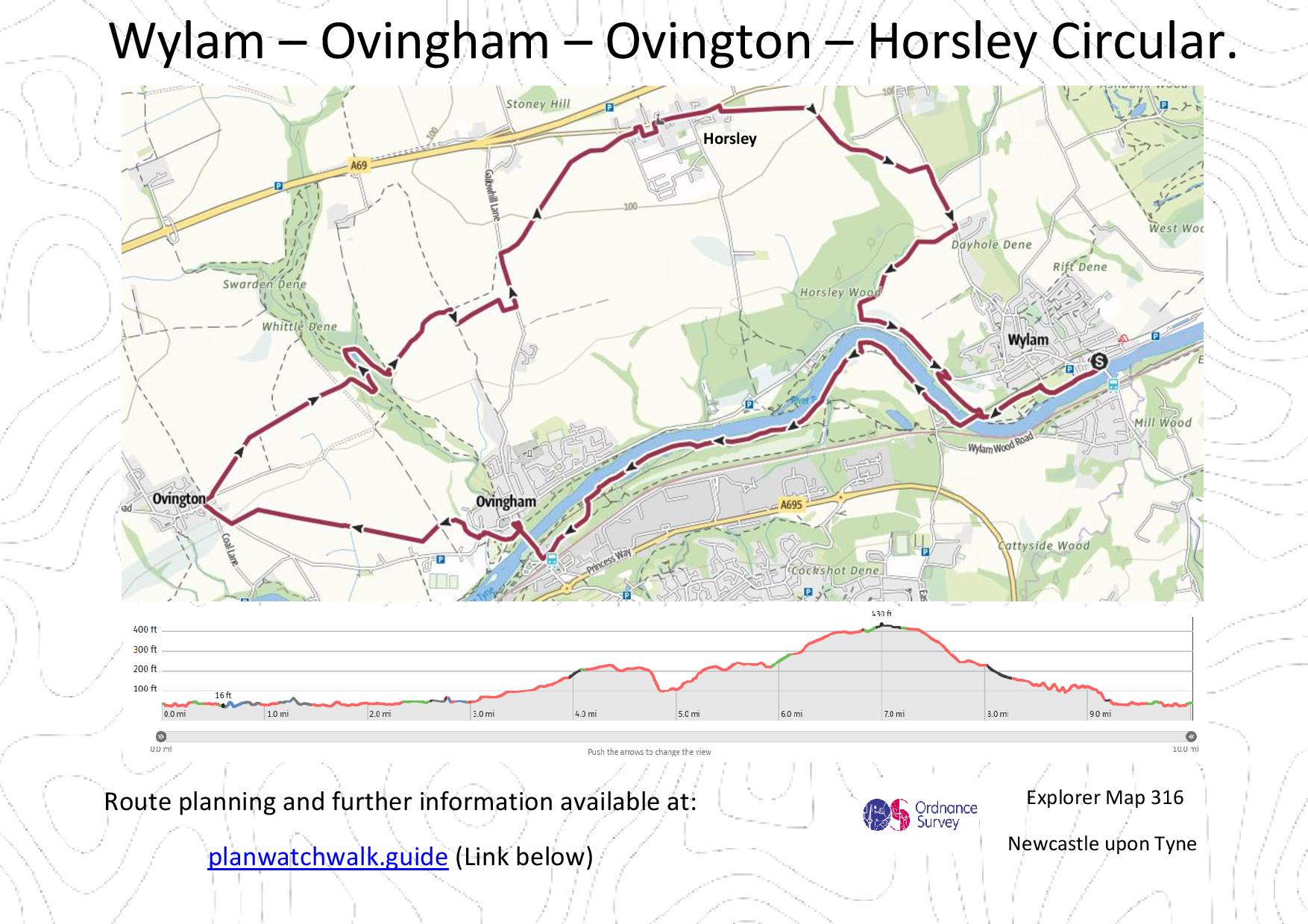
Turn by Turn Directions
Commencing our walk in Wylam by the war memorial (Video 1:00) and head down towards the River Tyne, passing some cottages on our right (Video 1:15), picking up a path which takes us along the side of the Tyne. On reaching Hagg Bank Bridge we cross to the southern side of the Tyne (Video 2:00). The path along the Tyne is very rewarding as we pass through wooded trails and open countryside on our way to Ovingham. Crossing over the Ovingham Bridge, there is a great view across the Tyne (Video 4:20), before coming to St Mary the Virgin Church ahead of us (Video 4:50). At the church we turn left and head through Ovingham. At Bridge End Inn, we cross the bridge and head right over the fields (Video 5:20).
We head over the fields, following the path signs on our way to Ovington. We have some nice views up the Tyne Valley as we go. On reaching Ovington we pick up St Andrew’s Lane and head east on our way to Whittle Dean, again we have great views (Video 9:30).
On reaching Whittle Dean we pass over Whittle Burn as we have some enjoyable woodland walking. On leaving the wooded area we follow the route and come to Gallowhill Lane, which we pass, on our way to Horsley. As we leave Horsley, we pick up the footpath signs for Wylam (Video 15:35). The path at this point is heard to pick up see video (Video 16:10).
Following the public footpath signs, we come to Horsley Wood, and have a great view across the Tyne (Video 19:45). Dropping down towards the Tune again, we pick up Ovingham Road before reaching Hagg Bank Bridge once again. We retrace our track to reach the conclusion of the very pleasant and rewarding walk.
Outdoor Catch-Up:
PWW searches for the best outdoor clothing offer and circulates these through our Outdoor Catch-Up communication, don’t forget to subscribe to some of the best offer available, we do the hard work for you. Subscribe at www.planwatchwalk.guide/outdoor-catch-up
Mapping and Directions:
OS Map App – Ordnance Survey Maps and routing – https://tidd.ly/3Xi32AJ
Maps – Ordnance Survey Maps – https://tidd.ly/3vTKOK0
Compass – Must have – https://tidd.ly/3XeDynV
Equipment used:
Jacket – Rab Microlight Alpine Jacket – https://tidd.ly/3iqUU26
Jacket – Montane Gravity Gore-Tex Jacket – https://tidd.ly/3Zq6HhF
Footwear – Merrell Accentor Sport GTX – https://tidd.ly/3Czkqct
Boots – Scarpa Rush Trek GTX – https://tidd.ly/3IHWEyu
Trousers – Montane BMC Terra Pants – https://tidd.ly/3QoR3iq
Waterproof Trousers – Mountain Hardwear Epic Pant – https://tidd.ly/3CveZeo
Socks – 1000 mile wool fusion double layer – https://tidd.ly/3ZqdIz1
Head Torch – Lifesystems Intensity 220 Head Torch – https://tidd.ly/3k0zsBo
Backpack – Hi Gear Active22 – https://tidd.ly/3k5Rgva
Bladder – Camelbak 2.5L Hydration Reservoir – https://tidd.ly/3inJX18
Camera Kit
GoPro 5 – Go anywhere action camera – https://amzn.to/3WV2OQ5
hohem iSteady Pro 4-Gimbal stabiliser – Making your video professional – https://amzn.to/3Xi1BCs
Lavalier Microphone – Capture professional audio – https://amzn.to/3XfjP7p
Insta360 ONE X2-360 Degree Camera – brining video to a new dimension – https://amzn.to/3jSgo8i
Insta360 3M (10ft) Invisible Selfie Stick – make it look like a drone – https://amzn.to/3VXf8hu
This post contains affiliated links, and I may earn a small commission when you click and purchase through these links. This is at no cost to you. Thank you for your support.

